Practical / The map that matters
One map of
the bits you use.
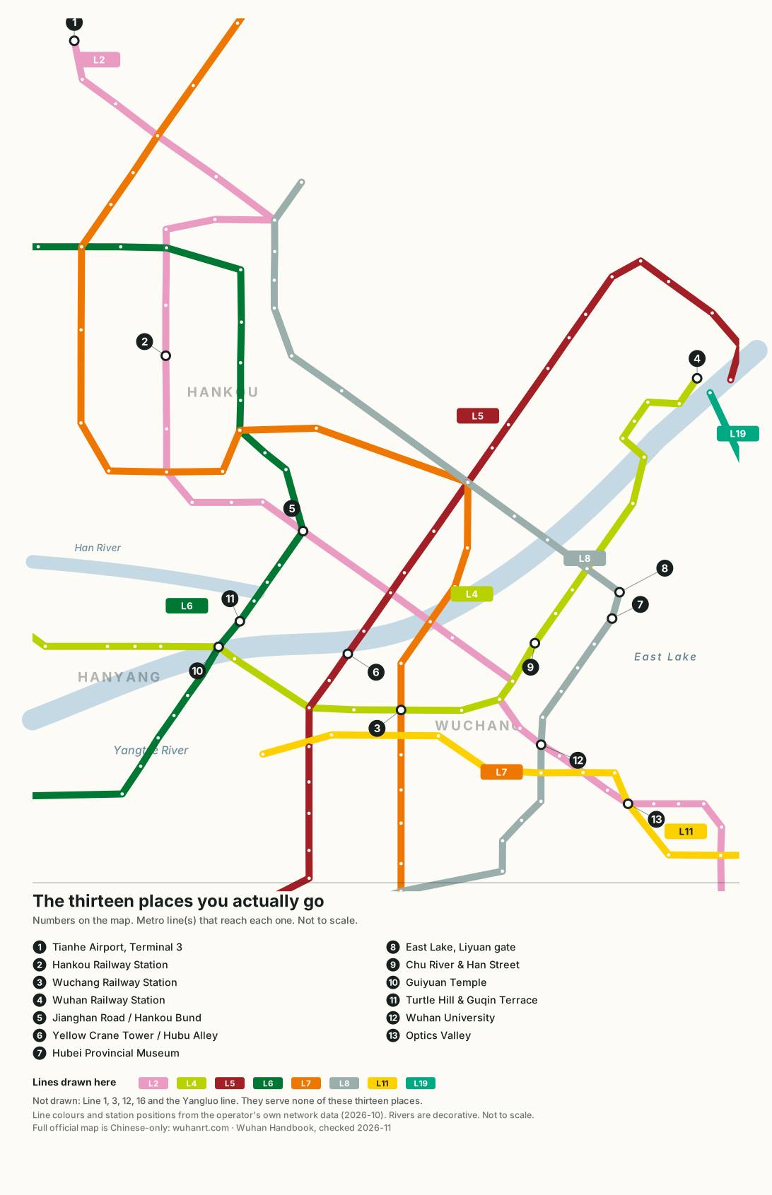
The official Wuhan metro map shows thirteen lines and 351 stations. You will use eight of those lines and thirteen places on them. This is that map, drawn from the operator's own geometry.
Everything a visitor needs hangs off one line: Line 2 runs from Tianhe Airport through Hankou Railway Station and Jianghan Road to Optics Valley. The other three gateways each sit on their own line — Wuchang Station on Lines 4 and 7, Wuhan Station on Lines 4, 5 and 19 — and the sights are distributed along Lines 4, 5, 6 and 8. Read the numbered nodes below, note which lines touch them, and you have the whole city in one picture. It is not to scale, and stop counts are not minutes.
A transport map is only useful if it is the size of your actual problem. The full English network map covers all thirteen lines and belongs on a different page for a different question. This one answers a narrower one: where are the four ways into the city, where are the things I came to see, and which line joins them.
How to read it
- Numbered circles are the thirteen places worth navigating to. The key at the foot of the map repeats them, so a saved copy is self-explanatory.
- Small outlined dots are ordinary stations on the eight lines drawn here — useful for counting stops, not worth naming.
- Coloured pills (L2, L4 and so on) name the line. Chinese signage uses 2号线, 4号线 — the number is what matters, not the word after it.
- The blue bands are the Yangtze and the Han River, drawn decoratively. They are there to tell you which bank you are on, not to be measured.
The four ways in
| Arriving at | Line | Straight to | Stops |
|---|---|---|---|
| Tianhe Airport (T3) | Line 2, terminus | Jianghan Road, the Hankou riverfront | 16 |
| Optics Valley (the far east side) | 27 | ||
| Hankou Railway Station | Line 2 | Jianghan Road | 6 |
| Wuhan University area (Jiedaokou) | 13 | ||
| Wuchang Railway Station | Line 4 | Chu River & Han Street | 4 |
| Line 4 | Guiyuan Temple (Zhongjiacun) | 4 | |
| Line 4 → 5 at Fuxing Road | Yellow Crane Tower | 2 + 2 | |
| Wuhan Railway Station | Line 4 | Chu River & Han Street | 10 |
| Line 5 | Yellow Crane Tower / Hubu Alley | 16 |
Stop counts are counted off the operator's station sequence, not estimated. Wuchang and Wuhan stations each have several exit squares that count as one station for ticketing — see which station.
We do not publish journey times for these routes, because the operator does not and our own measurements would be one person's afternoon. Sixteen stops on Line 2 from the airport is a long ride with luggage; two stops is not. Count the stations, add a change if the table says so, and treat any number of minutes you see elsewhere as somebody else's guess. The airport page covers the other ways in — taxi, bus — and what they cost.
Paying, and the one ticket worth knowing
Fares are distance-based and start at $0.30¥2 — Official / verified figure.. If you are going to make more than about four rides in a day, the day pass is the simpler decision: $2.69¥18 — Official / verified figure. for one day, $6.73¥45 — Official / verified figure. for three, $13.46¥90 — Official / verified figure. for seven. All three are the operator's published prices and all three are sold at station machines. Full detail on cards, QR codes and foreign bank cards is on pay and connect.
What this map leaves out, and why
Five lines are not drawn: Line 1 (the elevated light rail through north Hankou), Line 3, Line 12 (the loop), Line 16 and the Yangluo line. None of them serves any of the thirteen places above, and drawing them would double the ink for no decision it helps you make. If you are staying somewhere unusual, or heading to a suburb, you need the full network map instead — and for anything time-critical, the operator's own map at wuhanrt.com, which is Chinese-only.
Hankou is north of the Yangtze, Wuchang is south-east of it, Hanyang is the wedge between the two rivers. The metro crosses the Yangtze in several places, so "which bank is my hotel on" matters less than it used to — but it still decides whether your evening ends in the old city or on a bridge. The three-towns explanation is worth ten minutes before you book.
Honest catches
- Not to scale. The centre is stretched and the edges compressed, which is the point of a schematic — do not use it to estimate walking distances.
- The airport is genuinely far. Sixteen stops is not a rounding error; if you land late, check the last train before committing to the metro (alternatives).
- Two stations are not one place. Wuhan Station, Wuchang Station and Hankou Station all have multiple squares; the metro treats them as one station for fares but you can surface a ten-minute walk from your exit.
- Line 12 is a loop. It is not on this map, and if you end up on it you will be going around the outside of the city rather than across it.
- Signage is Chinese-first. Station names appear in pinyin, which helps; announcements and exit signs often do not. Have your destination written in characters (phrase cards).
Questions we keep seeing
How do I get from Wuhan airport to the city by metro?
Which metro line goes to the Yellow Crane Tower?
Which station is closest to the Hubei Provincial Museum and East Lake?
Is there a metro map in English?
Is a day pass worth it in Wuhan?
Does the metro go to all three railway stations?
Sources, prices and currency
Line colours, station positions, station sequences and the stop counts on this page are computed from the operator's own network data (wuhanrt.com metro-data, version 5418b46bfec8, network as of 29 October 2026) — the same source as the full English map, so the two cannot disagree. The selection of thirteen nodes, the numbering, the rivers and the district labels are our editorial choices. Fares and passes are the operator's published tariff (F71b); network size and hours are F71a and F71c. Journey times are deliberately not published: we have no verified per-route figures. Regenerate the map with python3 tools/gen-transit-map.py after any network change. Class B — re-check on each network update.
Every CNY amount on this page is shown twice: the yuan figure you will actually see on the price board, and a US dollar conversion for budgeting. Dollar values are mid-market conversions at 1 CNY = $0.14959 (ExchangeRate-API (open.er-api.com), 13 Nov 2026), refreshed automatically when the page loads and cached for 24 hours. Your bank or card issuer will use its own rate and may add a foreign-transaction fee. Full explanation.
Checked quarterly — hours, routes and venues. This page was last checked 2026-11.